THE U.S. COAST SURVEY: EARLY FOUNDATIONS
I. Political underpinnings
II. Pre- Civil War mapping
III. Nineteenth-century oceanography
IV. Role in the Civil War
II. Pre- Civil War mapping
III. Nineteenth-century oceanography
IV. Role in the Civil War
I. Political underpinnings
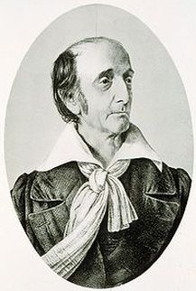
Ferdinand Hassler
After having navigated his chartered ship himself due to its captain's death aboard, Swiss geodist Ferdinand Hassler arrived in Philadelphia to find that the money he'd invested to found his own colony had been lost in speculation. Not one to give up to unfortunate fate, he gained American citizenship anyway and became actively involved in Philadelphia's scientific community and the American Philosophical Society, of which Thomas Jefferson was a member. Hassler quickly gained the respect of his peers, who proposed he become involved in surveying projects as he'd so successfully executed in Europe.
Within sixteen months of Hassler's arrival in America, the following act was passed by Congress on February 10, 1807: "Be it enacted by the Senate and House of Representatives of the United States of America in Congress assembled, That the President of the United States shall be, and he is hereby authorized and requested, to cause a survey to be taken of the coasts of the United States, in which shall be designated the islands and shoals, with the roads or places of anchorage, within twenty leagues of any part of the shores of the United States; and also the respective courses and distances between the principal capes, or head lands, together with such other matters as he may deem proper for completing an accurate chart of every part of the coasts within the extent aforesaid."
Hassler's proposal was selected as the best, but it took another nine years before he could begin work, first due to Jefferson's embargoes with England and France, then to a lack of instruments, then to the War of 1812. In the meantime, he served as a professor at West Point, then got stuck in England during the war, as he'd left just prior to its onset to procure instruments. Once able to begin, he requested the aid of the military for extra pairs of hands to little avail. Frustrated with the little progress, Congress ejected Hassler and his expertise from the project, halting progress for another 15 years. Lobbyists offering cheaper, faster results made offers, and Congress accepted one, handing the project to Navy Chaplain Cheever Felch who proposed a simpler, much less accurate approach to the Survey.
After working for a period for the Boundary Commission in determining the Canadian border, Hassler produced a document that traced the history and laid out his vision for what the survey could and should be in detailed methodology and philosophy. Eventually, in 1830, he was appointed the first Superintendent of the Office of Weights and Measures and began work on the Survey two years later, after President Jackson had transferred it to he Department of the Treasury. Two years later, the Survey was transferred to the Navy, then again back to the Treasury in 1837. Hassler fought to remain in control, his superior knowledge and commitment to science over politics eventually winning out.
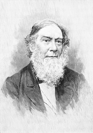
Alexander Bache
When Hassler died, the Survey was taken over by Alexander Bache, who took command at the beginning of a period of economic revitalization following the period of deflation that had occurred in the late 1830s. Bache oversaw the Survey during a period where more coastline was acquired than at any other point in the nation's history. The acquired new lands (and their economic value) such as Oregon, California, and Texas, allowed for the Survey's budget to be expanded from less than $100,000 in 1844 to over half a million dollars by the late 1850s.
Unlike Hassler, Bache was able to work with the scientifically-challenged politicians of the time, and secured greater autonomy for the Survey than Hassler was ever able to achieve. His political supporters ranged from left to right, and North to South. He garnered the support of several scientific lobbyists with great influence in Washington, and used his family connections (he was a great-grandson of Benjamin Franklin) as well. Eventually, due to Bache's efforts, the Survey became known as a public science, involving local workers and growing intrinsically linked to the communities it served, realizing Hassler's noble vision of the work being done for the sake of science and proper knowledge.
Unlike Hassler, Bache was able to work with the scientifically-challenged politicians of the time, and secured greater autonomy for the Survey than Hassler was ever able to achieve. His political supporters ranged from left to right, and North to South. He garnered the support of several scientific lobbyists with great influence in Washington, and used his family connections (he was a great-grandson of Benjamin Franklin) as well. Eventually, due to Bache's efforts, the Survey became known as a public science, involving local workers and growing intrinsically linked to the communities it served, realizing Hassler's noble vision of the work being done for the sake of science and proper knowledge.
II. Pre- Civil War mapping
When Jefferson established the U.S. Coast Survey in 1807, he selected Ferdinand Rudolph Hassler to head the survey. Hassler traveled to Europe to acquire the specific scientific instruments required, and did not return until 1815, after the end of the War of 1812 (NOAA). Hassler began surveying New York Harbor in 1817, and measured two baselines in New Jersey and Western Long Island (Allen, ch. 10). However, he was forced to stop in 1818, when civilians were prohibited from conducting surveys and the Army was put in charge. After 14 years of little progress under the Army’s leadership, Hassler was appointed superintendent, and in 1834, the agency took its first soundings (NOAA). The following year, they published their first map: a very accurate black and white print of Bridgeport Harbor, Connecticut (NOAA).
Map of Bridgeport Harbor, Connecticut, 1835.
Hassler mapped out all of Long Island, the area that has become the five boroughs of New York City, and most of the lower Hudson River Valley. He is most well known for his “New York Bay and Harbor and the Environs” charts that were completed in 1845, the year after his death. The published version was reproduced at a scale of 1:31,000, in slightly less detail than the manuscript versions, but still with enough precision to depict individual buildings, fields, marshes, woodlands, hills, streets, docks and parks. Compared to all previous charts of NY Harbor, Hassler’s chart used a much greater number of soundings and depicted standard navigational features (e.g. channels) in much greater detail. It also included a new channel, named “Gedney’s Channel.” Under Hassler’s instruction, Lieutenant Gedney discovered a more navigable channel (i.e. deeper and more direct) that led into New York Harbor – prior to discovery of this channel, ships had to sail through a channel near Sandy Hook, which was not deep enough for larger ships to sail at low tide (Allen, ch. 10). A similar discovery was made in the Delaware Bay in 1844, when Commander Blake found a safe channel through an area in the middle of the Bay referred to as Folger (NOAA).
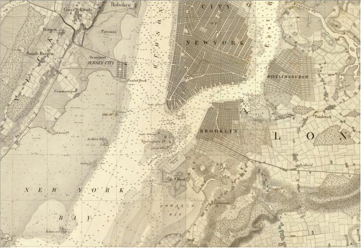
Portion of Hassler’s New York Harbor chart, 1845.
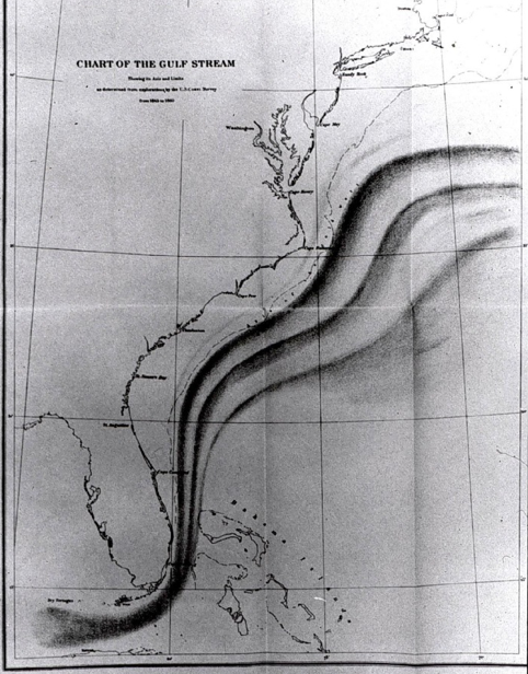
Gulf Stream, as studied between 1845 and 1860.
Alexander Dallas Bache took over the Coast Survey after Hassler’s death. He was responsible for the publication of Hassler’s maps, as well as extending the survey of the Hudson River Valley up to Albany. He was most well known, however, for turning the focus of the Coast Survey to new areas that had never been mapped before, namely the entire southern and western shores, extending to Florida and California. Within the first four years under Bache, the Survey expanded from working in nine states to working in seventeen states (NOAA).
Several important insights developed under Bache’s watch. His survey of the southern coast, which extended to the Florida Keys, along with his systematic observations of the Gulf Stream, lead to the publication of the First Tide Prediction Tables in 1853. Another important discovery occurred in the remapping of Nantucket Shoals, an area that was known for a large number of fatalities due to quick tide changes. The new surveys showed that there was another shoal (named the “Davey Shoal”), six miles south of the previously discovered shoal – accurate knowledge of the area decreased the number of fatalities. During the 1850s, new surveys of New York Harbor were conducted which showed drastic changes to the harbor since the first surveys had been conducted 20 years prior. For example, the addition of piers along the Hudson and East Rivers had altered tidal currents. Many of the changes were beneficial, but some were not, and this clearly demonstrated the need for continual surveying (NOAA).
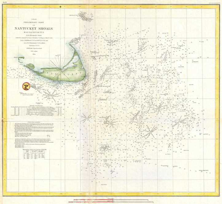
Nantucket Shoals chart, 1854.
After the conclusion of the Mexican War in 1850 and in the decade preceding the Civil War, the U.S. Coast Survey's mapping responsibilities extended beyond the Atlantic into the Pacific, as the agency began mapping the coastline of California, Oregon, and Washington. The first two survey ships employed in mapping the west coast of the United Sates, the Ewing and the Active, sailed around the Straights of Magellan in order to enter the Pacific (Cloud 8). These expeditions to the Pacific, as well as later expeditions via steamships, enabled the U.S. Cost Survey to produce some of the first accurate and detailed maps of the western coast as a whole as well as maps of important west coast bays and sounds (O'Hare).
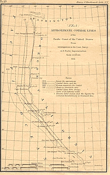
1855 U.S. Coast Survey map of the west coast of the United States.
III. Nineteenth-century oceanography
Beyond the immediate goal of mapping coastal waters for safe navigation, the U.S. Coast Survey was in the midst of the early emergence of oceanography as a science in the mid-nineteenth century and was responsible for developing several fundamental scientific concepts about the world's oceans. Prior to the mid-nineteenth century, little was known about the character of the ocean beyond the immediate coastline. How deep was the ocean? How far out did the continental shelf extend? How deep in the ocean could life survive? What were the physical, chemical, geological, and biological characteristics of the Gulf Stream? The U.S. Coast Survey, under superintendent Ferdinand Hassler and especially under Alexander Dallas Bache, aimed to answer these questions in its first few decades as a government organization.
The U.S. Coast Survey first attempted to answer the question of the ocean's greatest depth in 1840. Using the traditional sounding method of lowering a hemp rope over the side of a ship, Sir James Clark Ross made the first open ocean, deep-water sounding in the South Atlantic at 27S, 17W (Knight). He measured a depth of 2425 fathoms (14,450 ft.). Over the following decades, further sounding measurements were limited by the scope of the Coast Survey and its well-established efforts to map coastal waters for navigation; mappers were concerned with shallowness, not absolute depth. Nevertheless, important scientific discoveries were made in coastal waters, including soundings made in 1849 for Gulf Stream investigations that revealed the presence of a continental shelf break and the continental slope (Theberge). In 1857, the first deep sea-floor canyon was discovered by soundings taken in Monterey Bay by James Alden, commanding officer of the U.S. Coast Survey Steamer Active, while mapping the coast of California. The canyon Alden discovered, now known as the Monterey Canyon, extends 95 miles off the coast of California and reaches a depth of 11,800 feet (Knight).
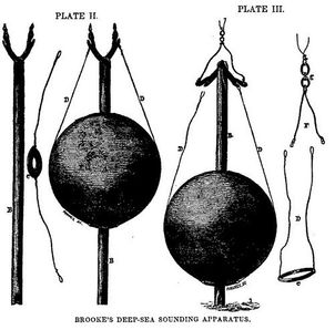
Different styles of sounding instruments developed by John M. Brooke, published in Matthew Fontaine Maury's 1855
The Physical Geography of the Sea.
The Physical Geography of the Sea.
During this two-decade period, the sounding instrument itself was developed and improved upon. Steel wire was attempted rather than hemp as a sounding line material. Different shape and size weights were also explored at the end of the sounding line. In order to collect samples of the seafloor, the weights themselves began to be coated in different waxy substances that would grab sediment and any small organisms the weight came in contact with (Rozwadowski 85). John M. Brooke of the U.S. Naval Observatory introduced a release mechanism for the sounding line weight. When the weight hit the seafloor, pins attaching the weight to the line were triggered, releasing the large circular weight but leaving the interior rod attached. This rod was used to collect seafloor samples and pulled back to the surface. Brooke's innovation not only ensured that the sounding line reached the seafloor, but it also limited the effects of the ship's motion and the currents on the measurement's accuracy (Birch Aquarium).
Brooke's improved sounding devices enabled U.S. Coast Survey scientist Louis F. de Pourtales to test hypotheses about the depth of life in the ocean. In 1843, the British naturalist Edward Forbes had speculated that life could not exist ad depths greater than 300 fathoms (1800 feet) below water (Knight). Forbes' declaration sent British and American naturalists alike on the hunt for the deepest life int he ocean, including de Pourtales, who found indications of life at depths over 1,000 fathoms on deep-sea sounding operations in 1853. de Pourtales expanded his search for the deepest life in the oceans by introducing dredging technology, whereby sediments and any life on the ocean floor are scraped into and captured in a bucket-like contraption and brought to the surface. Dredging off the coast of Florida in the Coast Survey steamers Corwin and Bib, de Pourtales found significant life at 517 fathoms, well deeper what Forbes had predicted (Theberge).
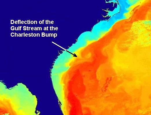
Modern image of the "Charleston Bump" and its effects on Gulf Stream flow, first recognized by captains in the U.S. Coast Survey fleet under the direction of Bache.
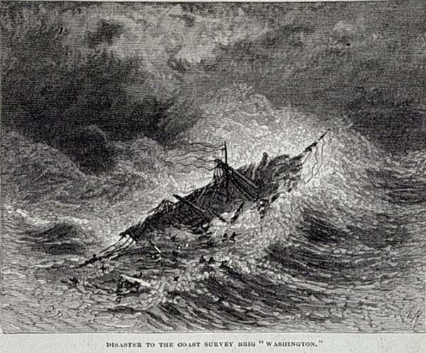
"Disaster to the Coast Survey brig 'Washington'."
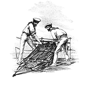
Cartoon of sailors pulling up a nineteenth-century style dredge.
Improved technology, along with the scientific vision of second superintendent Alexander Dallas Bache, led the U.S. Coast Survey to engage in long-term study of the Gulf Stream beginning in 1945. Bache issued specific instructions for systematic surveys of the Gulf Stream to one of his captians Charles Henry Davis. Bache wanted to know about the physical, chemical, geological, and biological nature of the Gulf Stream, and he envisioned repeated transect measurements during different times of the year over many years in a comprehensive study (Theberge). Although the Gulf Stream project was largely constrained by money and ship availability, Bache's crew of Coast Survey captains were able to make some critical observations:
1. Coast Survey expeditions discovered and named the "cold wall," a zone marking the high-temperature gradient between the warm Gulf Stream waters and the cold inshore waters to the north of Cape Hatteras.
2. The Coast Survey began to recognize some of the immense complexities of the Gulf Stream current, such as warm-cold water banding within the current.
3. The "Charleston Bump" was identified and its causal relationship to perturbations in Gulf Stream flow recognized (Theberge).
Bache's surveys of the Gulf Stream also lead to some of the first deaths caused the practice of oceanographic science in America. On September 8, 1846, eleven men aboard the U.S. Coast Survey Brig Washington were swept overboard during a hurricane off of Virginia while conducting measurements for the Gulf Stream study (Theberge).
Over 15 years Bach's captains and crew in the U.S. Coast Survey collected temperature, depth, current, biological, and geological surveys of the before the first U.S. Coast Survey map of the Gulf stream was published in 1860. The long-term study was halted by the onset of the Civil War, but the amount and quality of information that the Coast Survey collected in that time frame is considered pioneering and impressive, especially given the brief history of oceanography prior to Bache's appointment as superintendent. Bache is often hailed for his efforts to make the U.S. Coast Survey a scientific agency and to integrate science into the political agenda in Congress. Hugh Slotten writes, "Under Bache's direction, the Coast Survey became the largest and most important institution supporting science in antebellum America" (1).
It is important to note, however, that the scientific efforts of the U.S. Coast Survey were not unique. Both British-sponsored oceanographic explorations and undertakings of the U.S. Navy provided a wealth of knowledge about the oceans in the mid-nineteenth century. Because of the geoghraphic restriction of the U.S. Coast Survey to the coast, much of the exploration of the open oceans was left to the U.S. Naval Observatory and Hydrographic Office under the direction of Matthew Fountaine Maury (Theberge). Nevertheless, the U.S. Coast survey contributed valuable insights into our scientific understanding of the ocean during oceanography's inception as a science.
IV. Role in the Civil War
The role of the U.S. Coast Survey in the
American Civil War (1861-1865) is one that has been extremely overlooked by
contemporary historians and textbooks throughout the United States. The Coast
Survey provided essential information for the adequate and effective
implementation of the Southern Blockade which attempted to slowly destroy the
economy of the south. As a distinctive agrarian society, the Southern States
relied on their trade with Europe and Latin America for the bulk of their
economic prosperity. The North, acknowledging this, decided to strangle their
economy by cutting off the all entrances and throughways to the Gulf of Mexico,
the Atlantic Ocean, and various inland rivers. This extremely successful aspect
of the campaign would not have been possible if it were not
for the dedicated efforts of the U.S Coast Survey. However, before analyzing
the function of the U.S Coast Survey during the Civil War, it is essential to
see its development during the preceding years.
Alexander Dallas Bache became the Superintendent of the U.S Coast Survey in 1843, and would be at the helm of the organization through the Civil War. Bache, the great grandson of Benjamin Franklin and a major scientist of his era, was very well learned in the science of surveying. He developed a methodology which would be known as the “American Method,” which used the telegraph as a geodetic instrument to determine differences in the timing of astronomical observations and correlate these with differences in longitude. As John Cloud notes “…in the years under Bache before the war, the Survey and its associated military officers in both services gained a broad familiarity with many areas of the country, particularly the coastal areas of the southern states, where much of the Civil War would later be fought. They developed and invented or acquired new instruments, particularly emphasizing reduction in weight and size without impairing accuracy—instrument traits ideal for wartime applications. And, unlike the U.S. Navy, the Survey made the transition from sailing vessels to powered steamships well before the war, with important implications for their later military service (Cloud 8).” Essentially, the Survey under Bache’s leadership had unknowingly prepared and educated many military leaders, and the organization, on the area in which the Navy would be needed most during the war and also allowed for the development of methods and tactics which could be used there as well. It was almost as if they already had a head start to the war without even knowing it. To add insult to injury, when nearing the beginning of the war, the U.S Coast Survey recalled all its ships back to New York and cancelled most of its projects in the South prior to the beginning of the war. The ships began to be recalled due to the impending war and because of various reports of harassment at the hands of rebels in the south like in states like Texas and North Carolina. The South only managed to salvage two ships; the schooner Petrel and the steam tender Fire Fly, neither which survived to see the end of the war. In essence, the North entered the war knowing how to navigate the south’s waters, cut them off from the sea, and left them without ships to continue to survey their own waters.
Alexander Dallas Bache became the Superintendent of the U.S Coast Survey in 1843, and would be at the helm of the organization through the Civil War. Bache, the great grandson of Benjamin Franklin and a major scientist of his era, was very well learned in the science of surveying. He developed a methodology which would be known as the “American Method,” which used the telegraph as a geodetic instrument to determine differences in the timing of astronomical observations and correlate these with differences in longitude. As John Cloud notes “…in the years under Bache before the war, the Survey and its associated military officers in both services gained a broad familiarity with many areas of the country, particularly the coastal areas of the southern states, where much of the Civil War would later be fought. They developed and invented or acquired new instruments, particularly emphasizing reduction in weight and size without impairing accuracy—instrument traits ideal for wartime applications. And, unlike the U.S. Navy, the Survey made the transition from sailing vessels to powered steamships well before the war, with important implications for their later military service (Cloud 8).” Essentially, the Survey under Bache’s leadership had unknowingly prepared and educated many military leaders, and the organization, on the area in which the Navy would be needed most during the war and also allowed for the development of methods and tactics which could be used there as well. It was almost as if they already had a head start to the war without even knowing it. To add insult to injury, when nearing the beginning of the war, the U.S Coast Survey recalled all its ships back to New York and cancelled most of its projects in the South prior to the beginning of the war. The ships began to be recalled due to the impending war and because of various reports of harassment at the hands of rebels in the south like in states like Texas and North Carolina. The South only managed to salvage two ships; the schooner Petrel and the steam tender Fire Fly, neither which survived to see the end of the war. In essence, the North entered the war knowing how to navigate the south’s waters, cut them off from the sea, and left them without ships to continue to survey their own waters.
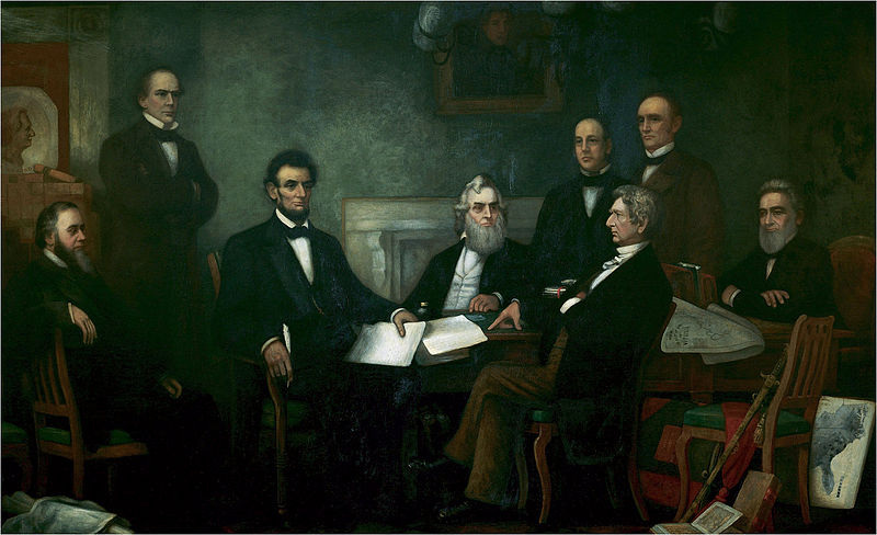
The First Reading of the Emancipation Proclamation by Francis B. Carpenter in 1864 shows two maps produced by the U.S Coast Survey:
the famous Slavery Map and a map of the State of Virginia.
the famous Slavery Map and a map of the State of Virginia.
In 1861, Bache
published the Survey’s annual report for the previous year which made the
newest charts readily available for the public. However, the report seemed to
overlook the impending war that was coming. It made no mention of any tensions
within the country. The texts, reports, and corresponding figures were printed
as usual. However, the usual “Index of Sketches” portion which provided many
charts of the different waterways in the United States was not printed, but
rather contained a note that said that some charts would not be published in
the anthology. Interestingly enough, the charts corresponded to waterways in
the Mississippi Sound in the Gulf of Mexico, coastal bays along the Florida
Coast, and the Atlantic Coast from Florida up to the Chesapeake Bay. These
charts, however, would be secretly printed as “Notes on the Coast” and would
not be made readily available to the public. Apart from clearing trying to hide
this information from the South, the U.S Survey would also form part of the
Blockade Strategy Board which would seek to cut off the Southern economy by
blocking its waterways and routes to its economic allies in Europe and Latin
America. After several meetings a plan was made to effectively cut the Southern
economy, and the strong Northern Navy implemented it.
However, this was no easy task. Thousands and thousands of coastline had to be covered, thus only the most important and essential areas could be patrolled. As Cloud portrays “The Blockade Strategy Board addressed these problems in a series of memoirs. These memoirs dealt with individual geographic regions of the Southeast coast. The first memoir dealt with the stretch of coast from Cape Henry, Virginia, to the southern limit of North Carolina; the second included the South Carolina coast; the third encompassed the Georgia coast and east coast of Florida; the fourth discussed the Gulf coast centered about the Mississippi River and approaches to New Orleans; and the fifth memoir dealt with the Florida Keys and reef, the west coast of Florida, western Louisiana, and Texas (Cloud17).” The Coast Survey then began to devise booklets with charts and scientific aids to guide the navy. They reproduced these “directions” and handed them out to the ships. The Coast Survey also succeeded in producing the “Notes on the Coast” memoirs which provided mariners with both aids on how to navigate through a location and its strategic value, which were distributed to the Union blockade squadrons. The Coast Survey also broadened in scope in June of 1861 when it produced its Virginia slave map which showed the population distribution of black slaves throughout the states. This map is important because it gave rise to the shading patterns that we see today to show different statistics. This also gave way to the use of color in the maps towards the end of the war which greatly enhanced the understanding of the charts and showed clear differences in heights, depths, and other statistical data. In essence, the U.S Coast Survey served as a pillar for the North’s fight against the south by providing crucial information in its successful attempt at crushing the Southern economy. But the war also gave way to great advances in the art and science of cartography.
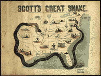
The Anaconda Plan, which the U.S Coast Survey helped create,
being portrayed in cartoon fashion.
being portrayed in cartoon fashion.
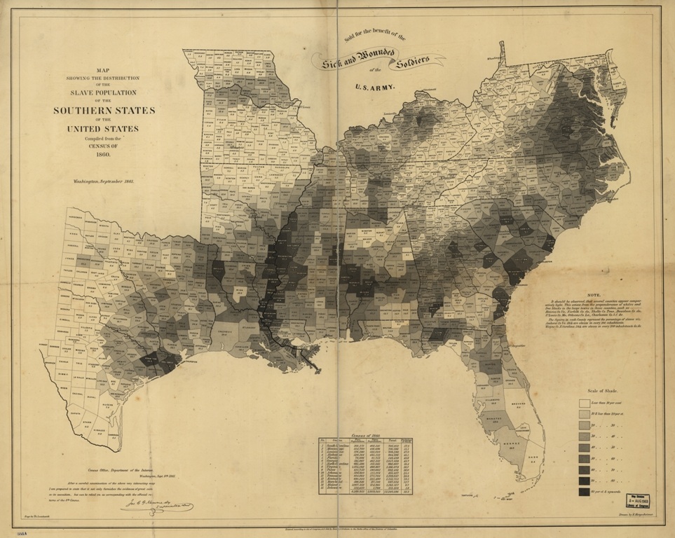
Created in September 1861 based on statistics from the eighth U.S. Census, this was the first map to show the slave distribution
in the United States.
in the United States.
